| rdf:type | ge:Borehole |
|---|---|
| m3d:usedFor | Calibration |
| rdf:type | m3d:PointCloud |
|---|---|
| m3d:usedFor | SurfaceInterpolation |
| rdf:type | ge:BoreholeLog |
|---|---|
| m3d:usedFor | BoreholeLogInterpretation |
| rdf:type | m3d:Task |
|---|---|
| m3d:deliverable | BoreholeDepthPointCloud-01 |
| ge:stratotype | StratigraphicPoint-01 |
|---|---|
| rdf:type | ge:GeochronologicBoundary |
| gsmltrs:nextEra | http://inspire.ec.europa.eu/codelist/GeochronologicEraValue/cenozoic |
| gsmltrs:previousEra | http://inspire.ec.europa.eu/codelist/GeochronologicEraValue/mesozoic |
| rdf:type | m3d:Task |
|---|---|
| m3d:deliverable | StratigraphicPoint-01 |
| rdf:type | dcat:Distribution |
|---|---|
| dcat:downloadURL | http://geonetwork.mfgi.hu:8080/wXmlDoc/getRecordById?id=preCenozoicSurface-01 |
| dct:format | "application/xml" |
| rdf:type | m3d:Task |
|---|---|
| m3d:deliverable | MappedContact-01 |
| rdf:type | gml:RectifiedGridCoverage |
|---|---|
| dcat:downloadURL | http://geonetwork.mfgi.hu:8080/wXmlDoc/getRecordById?id=COV_preCenozoicSurface-01 |
| rdf:type | m3d:Task |
|---|---|
| m3d:deliverable | SeismicTimeSection-01 |
| m3d:deliverable | SeismicTimeSection-02 |
| rdf:type | m3d:Task |
|---|---|
| m3d:deliverable | TravelTimePointCloud-01 |
| rdf:type | ge:MappedFeature |
|---|---|
| ge:specification | preCenozoicSurface-01 |
| ge:samplingFrame | SurfaceGridModel-01 |
| dct:description | "Mapped geological contract - 3D Grid surface of the pre-Cenozoic contact"@en |
| rdf:type | om:Observation |
|---|---|
| om:result | COV_preCenozoicSurface-01 |
| rdf:type | ge:Contact |
|---|---|
| ge:correlatesWith | Boundary-01 |
| dct:description | "Contact between Cenozoic and Mesozoic formations"@en |
| m3d:inspireDownload | CNT-01.inspire |
| rdf:type | rdf:Project |
|---|---|
| m3d:workPackage | Taska3D_WP1 |
| rdf:type | m3d:Task |
|---|---|
| m3d:deliverable | SeismicDepthPointCloud-01 |
| rdf:type | m3d:PointCloud |
|---|---|
| m3d:usedFor | SurfaceInterpolation |
| m3d:usedFor | ManualTracing |
|---|---|
| rdf:type | m3d:SurfaceModel |
| m3d:usedFor | ManualTracing |
|---|---|
| rdf:type | m3d:SurfaceModel |
| rdf:type | m3d:VoxelModel |
|---|---|
| m3d:usedFor | LineExtraction |
| rdf:type | dcat:Distribution |
|---|---|
| dcat:downloadURL | http://geonetwork.mfgi.hu:8080/wXmlDoc/getRecordById?id=SurfaceGridModel-01 |
| dct:format | "application/xml" |
| rdf:type | ge:StratigraphicPoint |
|---|---|
| m3d:usedFor | ManualTracing |
| m3d:usedFor | BoreholeLogInterpretation |
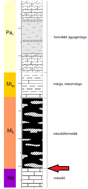
| dct:description | "Stratigraphic point identifying the contact between Cenozoic and Mesozoic formations at xxx m depth in borehole Tas-x"@en |
| m3d:inspireDownload | STRP-01.inspire |
| m3d:view | STRP-01.view |
| rdf:type | dcat:Distribution |
|---|---|
| dcat:downloadURL | http://geonetwork.mfgi.hu:8080/wXmlDoc/getRecordById?id=StratigraphicPoint-01 |
| dct:format | "application/xml" |
| rdf:type | dcat:Distribution |
|---|---|
| dcat:accessURL | http://geonetwork.mfgi.hu/test_m3d/taskaiForm.png |
| dct:format | "image/png" |
| dct:title | "View of Stratigraphic point STRP-01"@en |
| rdf:type | m3d:SurfaceModel |
|---|---|
| m3d:usedFor | ContactReconstruction |
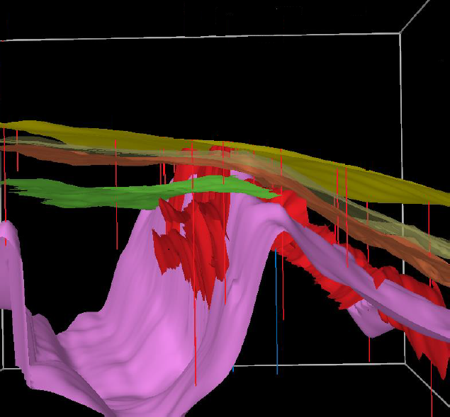
| dct:description | "3D Grid Surface Model of the pre-Cenozoic contact reconstructed from boreholes and 3D seismic data"@en |
| m3d:inspireDownload | SGM-01.inspire |
| om:relatedObservation | OBS_Interpolation-01 |
| rdf:type | m3d:Task |
|---|---|
| m3d:deliverable | SurfaceGridModel-01 |
| rdf:type | m3d:3DModel |
|---|---|
| ge:mapMember | MappedContact-01 |
| dct:title | "3D Geological Model of Taska area"@en |
| dct:description | "Demonstration of using semantic web and INSPIRE principles to describe 3D Geological Models"@en |
| dct:creator | "László Sőrés, MBFSZ"@hu |
| m3d:download | Taska3D.download |
| m3d:view | Taska3D.view |
| rdf:type | dcat:Distribution |
|---|---|
| dcat:downloadURL | http://geonetwork.mfgi.hu/test_m3d/download.html |
| rdf:type | dcat:Distribution |
|---|---|
| dcat:accessURL | http://geonetwork.mfgi.hu/test_m3d/taska3d.png |
| dct:format | "image/png" |
| rdf:type | m3d:WorkPackage |
|---|---|
| m3d:product | MappedContact-01 |
| m3d:task | ManualTracing |
| m3d:task | SeismicDepthConversion |
| m3d:task | BoreholeLogInterpretation |
| m3d:task | SurfaceInterpolation |
| m3d:task | ContactReconstruction |
| m3d:task | Calibration |
| m3d:task | LineExtraction |
| rdf:type | m3d:PointCloud |
|---|---|
| m3d:usedFor | SeismicDepthConversion |